|
|
 |
Guest - Not logged in | |||||||||||||||||||||||||||||||||||||||||||
Reviews > Books > Trail Guides > Mountain Footseps > Owner Review by Andrea MurlandMountain
Footsteps Tester Information
I began hiking frequently in 2006 and have since hiked in Western Canada, Australia, and spent 2 months backpacking in the Alps. I spend most weekends either day-hiking or on 2-3 day backpacking trips, with some longer trips when I can manage them. I also snowshoe and ski in the winter, but don’t have a lot of experience with winter in the backcountry yet. Elevation is typically 500-3,000 m (1,600-10,000 ft), in the Canadian Rockies and the Selkirk, Purcell, and Monashee ranges. I try for a light pack, but I don’t consider myself a lightweight backpacker. Product Information
Description “Mountain Footsteps” is a hiking guide for the local area where I live. The book lists 88 hikes, though some of those listed consist of an overview of multiple trails in an area, and many hikes describe further exploration that can be done in the same area, so there are certainly more than 88 hiking options in the book. The book is focused on the East Kootenay, a region which encompasses, generally, the area west of the British Columbia/Alberta border, north of the Canada/United States border, south of the Rocky Mountain National Parks (such as Banff), and east of the West Kootenays. The author has divided this area into four: the Northern Purcells, Southern Purcells, Northern Rockies, and Southern Rockies. A map right at the front of the book shows these four areas, along with highways and park boundaries.I will note that the author has a separate web page which has quite a lot of useful information. This includes information on hikes included in previous editions but removed from this one, and a forum for updates on backcountry road conditions. I try to make a point of checking it before heading out. Field Conditions I received this book in late 2011, and have used it quite a bit in the past three years. I have done nineteen of the hikes so far. I have never carried the actual book on a hike, as I usually remember to make a photocopy of the description for the hike I’m planning. I often have the book in the car for driving directions, but leave it there when I reach the trailhead. My book is still in pretty pristine condition for a hiking guide!Layout
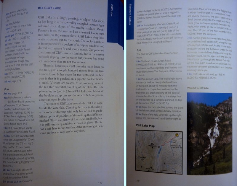
After the Contents is a series of sections of information. These include how to read the driving and hiking directions (e.g. hiking distances are one-way, and definitions of what the vehicle ratings mean), a map legend, information about the area, how to hike safely, and precautions to take. At the beginning of each of the four sections of the book (corresponding to the four areas) there is a more detailed road map of the area, showing highways and major backcountry roads. These maps also show the general location of each hike or group of hikes. Now, the hike descriptions themselves. I have taken a picture of the description for a hike that I did in June 2014, and will use that to help explain. This particular hike, #45 Cliff Lake, is in the Southern Rockies. All of the hike description pages have several sections. On the main part of the page, under the heading, in decent sized text, is a general description of the hike and surroundings. This may include landmarks, descriptions of the valleys, some basic history, and camping information. Each page also has a sidebar on the left in small text, with the real details. The first part of the sidebar gives pertinent information about the hike: rating, time, distance, elevation gain, key elevation, a short description of trail conditions, and the topographical map sheets for the area. Below that is a section called “Drive”, which starts with listing what page the road map can be found on in the book, a description of the type of vehicle required, and then detailed driving directions from a major landmark. Then comes a section called “Trail”, with detailed trail directions by distance. If the sidebar details are considerably longer than the general description, they often turn into two columns on the final page, as can be seen in the case of Cliff Lake. Most of the hikes (or groups of hikes in close proximity) also have a small trail map. These maps show contour lines and the location of the trail and major points of interest (camping, restrooms, summits, etc.), but I wouldn’t consider them suitable for navigation. They are a useful reference though.
My
Thoughts
Summary
Read more reviews of Rocky Mountain Books gear Read more gear reviews by Andrea Murland Reviews > Books > Trail Guides > Mountain Footseps > Owner Review by Andrea Murland | ||||||||||||||||||||||||||||||||||||||||||||