

|
|
 |
Guest - Not logged in | |||
Reviews > Navigation and Map Gear > GPS > Garmin eTrex 20 > Owner Review by joe schafferGarmin
eTrex 20
Owner Review by Joe Schaffer
REVIEWER
INFORMATION: May 27, 2019 NAME: Joe Schaffer EMAIL: never2muchstuff(at)yahoo(dot)com AGE: 71 GENDER: Male HOME: Bay Area, California USA I enjoy California's central Sierras, camping every month with a goal to match my age in nights out each year. For comfort I lug tent, mattress, chair and such. Typical summer trips run 5-8 days; 40 lb (18 kg), about half food and water related; about 5 miles (8 km) per hiking day in the bright and sunny granite in and around Yosemite. I winter base camp most often at 6,000 to 7,000 ft (1,800 to 2,000 m); 2 to 3 nights; 50 lb (23 kg); a mile or so (1.6 km) on snowshoes.
Product:
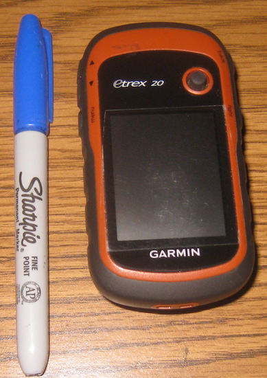 eTrex 20 GPS eTrex 20 GPSManufacturer: Garmin, Inc. Website: https://www.garmin.com Product # 010-01508-00 Waterproof Handheld GPS w/ Basemap Transflective 65-K Color TFT Display 1.7 GB Built-in Memory Accepts microSD(TM) Data Card Automatic Routing Custom Maps Compatible Tide Tables Compatible Custom Points Of Interest Garmin Connect(TM) Compatible Routes: 200; Waypoints: 2000; Track log: 10,000 points, 200 saved tracks Cost: US $199.99 Purchased: around 2014 My Specs: Weight: 5 1/8 oz (146 g) with two AA batteries Length: 3 7/8 in (98 mm) Width: 2 1/8 in (54 mm) stowed Max thickness: about 1 1/2 in (38 mm) My Description: The eTrex 20 is a handheld color-screen GPS operated with buttons (not touch screen). All functions are available using one hand only, though of course two hands can be used. The screen features technology that makes content very legible in sunlight. It will talk to as many as twelve satellites, though I've never gotten more than eight; and it will locate with as few as three. Direction and altitude are derived from satellite input. It is somewhat more sensitive than earlier (pre-2014) models and my experience suggests it connects about 90% of the time. The unit will hold a map chip, which then gives the user very high map detail. (Though the unit has a built-in base map of major roads and points, for backpacking without a map chip the device is good for little more than marking and finding waypoints and track logs.) The device electro  nics
are sealed against water intrusion; the battery case can get wet
inside. There is a lanyard anchor on the bottom of the device.
Connection to computer is via micro USB. nics
are sealed against water intrusion; the battery case can get wet
inside. There is a lanyard anchor on the bottom of the device.
Connection to computer is via micro USB.Device buttons are: Right side: top corner--back page; near top--On/off and brightness on the same button. Left side top--Zoom buttons; near top--menu button. Face: Toggle switch for executing commands and for moving about the map. Field Conditions: I carry the device with me on most outings. I've used the unit in weather conditions from hot to snowing; pitch black to bright sun; bottom of canyons to top of ridges. It prefers a wide open view of the sky. It will connect through a car windshield and often through a tent, but can prevaricate in dense tree cover or canyon walls. In one of the best field experiences, I'd hiked in unexpected snow for over 10 mi (15 km) fleeing to Camp Lake by dark. It was October and with eight inches (20 cm) already on the ground I didn't know how much more might accumulate overnight. Not wanting to risk getting snowbound, I bet on my headlamp and eTrex 20 to make it 2 mi (3 km) more to the car. At 0.25 mi (0.4 km) from the car the unit refused satellite contact. I was so tired and disoriented that I flopped around for a half-hour trying to find any evidence of where I was. Eventually tripping over a curb in the parking lot I still struggled to find my car, the only one there. The frustrating finish did not distract me from my mission to get out that night; which without the eTrex 20 I would not have attempted. The user trail into Bergson Lake is easy to lose, especially by headlamp, and scampering over some granite I got completely disheveled. I whipped out the eTrex 20 with massive confidence, only to have it refuse to give direction. It did yield distance. Eventually I found the lake by trial-and-error walking until the unit would (somewhat stubbornly) refresh the distance. Without the unit I would have had to dry-camp in place until daylight. Even earned confidence can be misplaced. A buddy and I left the car in the dark and 21 F (-7 C) on a trail we did not know, but was on the map chip. After a mile (1.5 k) or so we came to blow down and lost the trail. No problem, fire up the geeps. We were on steep, heavily wooded mountainside, yet the device graciously cooperated. It indicated the trail 0.2 mi (0.3 km) downhill. I didn't think we would have wandered that far off, but I've learned to take little stock in my senses and more in the map. We persisted until exhaustion and cold forced us to find any flat spot on which we could pitch our tents, which we decided would more likely be back uphill above the brush in which we'd been mired. In the morning I saw that his flat spot 30 yards (30 m) away was the trail, and mine literally spitting distance above it. Two trees had fallen toward each other, conspiring to obscure about 100 feet (30 m) of trail. The map chip was simply wrong about the trail's precise location in that specific area. The odds of that would be..? On the other hand: At about 13,000 feet (4,000 m) in the dark on Mt. Shasta I had a nagging sense of being off route. Consulting a compass and the eTrex 20 I concluded both devices were the same 90 degrees off. My three compadres when asked which way to go unanimously pointed in a direction confirming my conclusion. Score? Two devices correct, four hikers wrong. Impressions: As an electronic device it has a brain to know when not working will cause the greatest amount of trouble. I have learned to abide the manufacturer's admonition not to rely on it as a sole navigation device. So said, I will go anywhere anytime with it. Once darkness falls I don't find a compass and map very useful; and I've had many fine outings hiking in the dark. I use the unit primarily for navigation (always have compass and paper map). It will accommodate and I purchased a map chip (US $100) with high detail. The screen is small. It's not very practical trying to get a big picture of where on earth I am. With a chip the unit pinpoints the location over underlying map detail. Without a chip the unit will still pinpoint the location, but with no underlying map detail and only coordinates as the readout, the location can be difficult to translate to a map. The chip usually lets me navigate trail I can't see, obscured by snow or lost in brush. It is sometimes useful for interpreting terrain and negotiating best path on contours and to cross-country destinations. The unit also can be quite useful in divining distances. To be honest, I don't always know exactly where I am. Actually, I almost never have a clue, and to my disadvantage I have virtually no internal compass. I resist admitting that, so I often think I can walk an unaided straight line. When it becomes obvious I'm not getting where I should, the GPS usually gets me back on track. There have been a few occasions where it wouldn't, and I was forced to camp and wait for daylight. Gadgets generally don't ring my bell, but GPS has brought a dimension of backpacking to which I have become thoroughly attached. This is my fourth unit. It does some stuff I'll never care about. It does not have an altimeter, which I kind of miss because the barometer function can help predict changes in weather. It does not have an electronic compass, and when struggling to maintain three satellites it has on occasion gone completely schizoid bouncing from one to another. It does not have a quad-helix antenna, generally regarded as being more sensitive. Yet I prefer the eTrex 20 because it holds a map chip and it works generally well for navigating back country. It's light and small. Battery life is satisfactory, important to me as I don't carry spares. It is the least expensive Garmin for my backcountry navigation needs; i.e., holds a map chip. Spending twice as much would not make me any happier; and would only exponentially increase the reach of the devil to snatch it into the black hole. When things are working properly, which for a while hasn't been the case, the desktop computer will read the map chip in the unit using Garmin BaseCamp, a free download. This allows routing and waypoints to go to (and from) the unit without having to patch through other map software; and to print a map cloning the unit's. By some quirk of coincidence, the chip's map displays the area I go to most of the time; but has blanked out almost everywhere else. I don't know how long that's been the case; and of course I'm way beyond warranty. Once again, reason not to get too crazy in spending for this stuff. Quick shots: a) light b) small c) usually locates d) holds a chip Read more reviews of Garmin gear Read more gear reviews by joe schaffer Reviews > Navigation and Map Gear > GPS > Garmin eTrex 20 > Owner Review by joe schaffer | ||||