

|
|
 |
Guest - Not logged in | |||||||||||||||||||||||||||||
Reviews > Navigation and Map Gear > GPS > Magellan eXplorist 710 GPS > Test Report by Lori PontiousMagellan eXplorist 710
INITIAL REPORT - September 27, 2011 Tester Information
I backpacked, camped and fished all over the lower 48 states with my family as a kid, and then life happened. I restarted these activities about four years ago - I dayhike or backpack 2-6 times a month. I am between light and ultralight. I have a hammock system and own a Tarptent. My base weight depends upon season and where I go. Product information
The Magellan eXplorist 710 (hereafter the unit, the GPS or the eXplorist) is a full featured GPS unit with a touch screen. The eXplorist arrived in new condition, no blemishes or defects in appearance or in operation (so far). The box contained the GPS, a USB cable, a pair of AA lithium batteries, and a quick start guide. There was also a $2 rebate for more lithium batteries and a slip of paper providing a code for a 30 day trial of the premium membership at Geocaching.com. The unit has a speaker and camera on the back plate. Removing the back plate I found the battery compartment, where there is also a slot for an SD card. The front of the GPS was protected by a peel-off clear film. There is no lanyard included, nor any mounting hardware, nor any software. The GPS itself appears durable, without any protruding plastic bits that might break off. The USB connector plugs into a USB-A slot beneath a small cap that I pry up with a fingernail, at the bottom of the unit. A slot for mounting hardware runs vertically down the removable panel. The camera and speaker are on either side of the battery panel latch. Other than the two reprogrammable buttons and the power button, there is only the touch screen interface to control/adjust settings on the unit. 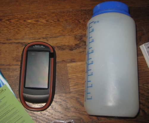 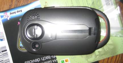 Initial Report Before settling in with the manual (only available online in digital format, or by order from Magellan), I powered up the unit and explored the menus. Since I have prior GPS experience I could appreciate a few extra features in addition to the settings to which I am accustomed; not only can I set the GPS to UTM coordinates, I can also view a secondary set of coordinates in degrees and minutes - this is particularly interesting to me as a feature due to the nature of search and rescue. My local volunteer search and rescue team uses UTM, while our neighboring counties and the national parks use latitude and longitude, and being able to quickly pull coordinates in either will come in handy! The eXplorist has many menus and features to explore. One can access the menus by tapping on the screen; in the corners of the screen icons appear. The upper left hand corner icon will feature a shortcut to the last setting changed and saved. The other corner icons are preset to icons that will access waypoint and track settings (lower right hand corner), configurable shortcuts to home, base camp, the car, or any other location I decide I want to make a shortcut to (upper right hand corner), and a menu for accessing track save, waypoints, maps, geocaches stored in the GPS, and points of interest (lower left hand corner). Most menus have a back button at the bottom of the screen. Profiles are preset for hiking, geocaching, marine, vehicle, pedestrian, or bike travel. There are also two user configurable buttons. Each profile will allow for setting units of measure, map options, track logging mode, sensors and alarms. I appreciate the profiles as they allow for quick switching between travel in the car and leaving the car to hike. I took the GPS out for a walk, upon discovering a geocache had been placed within a mile of home. While I did not locate the cache, which was evidently very small, I did get an idea of how easy it is to use the GPS for this purpose. The downloaded information I can access on the screen includes hints, description of the cache, and any comments uploaded to the geocaching.com website by others who have looked for the cache. I am given the option to mark the cache found, not found, or needing maintenance, and to leave a comment for future cache seeker's reference to upload to the website later. While following a track the pointer on the screen changes color; when on track, the pointer turns green. When not using the unit to navigate to a specific point selected, the pointer stays blue but rotates as the user re-orients the GPS. I also used the unit for a test drive, with the profile set to vehicle. In this mode the unit will provide spoken prompts to turn left or right, at regular intervals as I approach intersections. The unit will adjust if I miss the turn (which I did deliberately) and prompt me to take corrective action, such as turning right and going around the block. It's fairly straightforward using the unit in this manner, though it would be easier for me if I had mounting hardware to put the unit on the dashboard instead of keeping it in the cup holder. I took a sample picture with the unit and was able to attach it to a waypoint. The camera can be set to four different sizes, to normal, fine or HD quality, and to sort pictures by name, date or distance. The camera will capture still shots as well as videos. I have not yet uploaded waypoints or track information to the software on my PC, but have been able to access photos stored on the GPS via my computer, as the GPS will appear on my Macintosh or my PC as an external hard drive. In summary, I am still exploring and developing an understanding of the eXplorist's many features, and learning how to access settings I want to change. So far the GPS has been easy for me to use. I did find that the road navigation was not as efficient as it could have been, routing me in curious ways, but the voice prompts are easy to follow (once I turn down the volume of the Rolling Stones CD and turn up the GPS volume) and adapted to changes of route. There are far more settings and menu options than I have yet cataloged, and I am still reading the manual. I will continue to delve into the menus and features over the next two months. Field Report Field Locations/Usage Montana de Oro State Park, California, September 24 - 25, driving, geocaching, hiking Courtright Reservoir, Sierra National Forest, California, October 1 - 2, driving, geocaching, kayaking Wishon Reservoir, Sierra National Forest, California, October 8 - 9, driving, geocaching, kayaking San Joaquin River between Lost Lake and the Sportsman's Club, Fresno, California, app. 8 miles by kayak Big Basin State Park, Santa Cruz Mountains, California, October 29 - 31, driving, hiking Twin Lakes, Kaiser Wilderness, Sierra National Forest, California, November 1, driving, hiking Big Tabletop, Millerton State Recreation Area, California, November 3, hiking Redinger Lake, Sierra National Forest, California, November 5, kayaking San Joaquin River Gorge/Millerton State Recreation Area, California, November 6, hiking Eastman Lake, California, November 12 - 13, hiking, driving, geocaching Sykes Hot Springs, Ventana Wilderness, Los Padres National Forest, California, November 21 - 22, backpacking Frog Lake, Henry Coe State Park, Morgan Hill, California, December 4 - 5, backpacking I have also used the eXplorist on three afternoons when I had time to drive around town geocaching. Observations Generally, my usual use of the GPS while hiking is as follows. I attached a lanyard to the GPS and have worn it around my neck, but more often attached it to a belt loop with a clip and tucked the GPS in a cargo pocket on my pants. Letting the unit swing around tends to result in the logging of speeds up to 9 miles per hour, which is not my top hiking speed by any means. I consult the GPS frequently - attempting to monitor the battery life as well as monitoring satellite connection and track recording, and to take pictures or check coordinates. At the beginning of each route or hike, I clear the trip meter, trip odometer, calibrate the compass (and barometer and altimeter, if I haven't done so in a while), and either save or discard the active track to start a new one. These functions are accessed through the dashboard, which I have programmed to be activated by one of the configurable buttons on the side of the GPS. The dashboard gives me information such as time travelled, average speed, moving average, moving time, stopped time, and information on quality of the satellite connection and accuracy of the GPS. I find myself wishing that there was a control or button that would allow me to reset these things with one touch, or to configure it to reset the data points I prefer to use to monitor my time and speed. It would be more convenient than standing for five minutes clicking through menus. During this phase of testing, I had the GPS on while traveling, sometimes locking the screen to prevent accidental activation. The touch screen is responsive and I found the menus fairly easy to navigate. I most often use the menus off the bottom two corners of the screen; setting waypoints, pausing or canceling routes, pausing or canceling tracks and locking the screen are options off the lower right hand corner, and most general settings and all features including profiles are available through the lower left hand corner menu. Locking the screen keeps the GPS from responding to inadvertent contacts. I configured the smaller of the two side buttons to set waypoints. Naming waypoints is automated; the GPS will use the name of the last waypoint as a template and add a number incrementally, so my last overnight trip has waypoints sykes, sykes1, sykes2, etc. Neglecting to rename the first waypoint on a trip results in tedium as I then have to go back and rename all the waypoints to something meaningful after the fact, one by one. 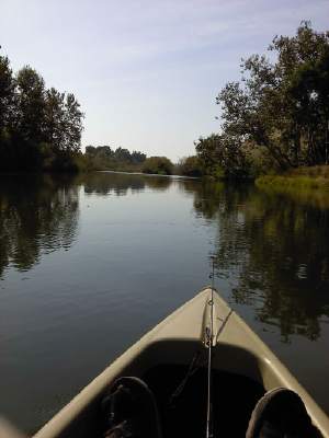 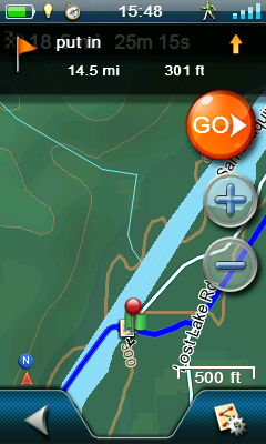 Here is a picture taken by the GPS, and a screen shot. I drove to a day use area along the San Joaquin River and put in a tandem kayak, and we went in search of bass and trout. On the screen shot the put in is waypointed and a picture attached to the spot. Across the top the icons tell me I have good battery charge, I have calibrated the compass, set the time display to military time, left the unit in hiking mode, and there's good satellite connection. I can tell by the pin on the waypoint that I am looking at the put in from where we left the river - the blue line is the route we drove to the put in and then got in the kayak and went downriver. From this screen I can touch Go and it will navigate me turn by turn back to the truck. The pin is the icon used when marking a point by touching the screen; I scrolled up the map and touched the waypoint instead of selecting it from the waypoint menu. It is easy to scroll around with a finger's touch on the map, tap on a location, and tell the GPS to begin navigating to it. On all occasions using the unit while driving, I found that the eXplorist did well in giving me instructions with enough lead time to change lanes or prepare for turns or freeway exits. The GPS will prompt me at intervals of two miles (3 km), one mile (1.6 km), and half a mile (.8 km) to provide time to prepare for course changes and make a two note sound within a car length (generally) of the turn to alert me that I am at the turn. On most of the driving routes I was familiar with the course I needed to take and several times did not take the GPS indicated route. When this happens the unit will start to instruct me to make a legal U turn, or to turn right to take a route back to the point where the GPS wanted me to turn. As I continued on the route I chose, the GPS adjusted and began to route me toward the destination again, adapting to my disobedience. There were two occasions when the GPS was blatantly incorrect, but to be fair, we were on country roads and no GPS can be completely infallible. I feel that it does an excellent job with directing me while driving, though at times it took a slightly longer route than was available. One of the features I appreciated while traveling long distances was the POI (Points of Interest) accessed from the lower left corner menu - In a new town and unfamiliar with local amenities, I found it helpful to have a categorized list of recreational facilities, restaurants, hospitals and other resources. I used the restaurant listings to locate a quick meal on several occasions, and with the touch of a button the GPS will direct me to the location. I also found that it will not find McDonalds for me - a GPS with good taste? While it does not have a comprehensive listing of all facilities in an area, I found it very helpful to have. With the search function it even becomes a quick access to directions to a restaurant I already know exists, but cannot remember the cross streets or address. While using the GPS while hiking, I quickly learned that the icons across the top of the screen are important, especially the third one from the left that indicates the status of the compass. Any GPS requires that the compass be calibrated often. I have calibrated the unit at each trailhead. If for some reason the compass loses the calibration, the icon at the top of the screen turns red. On one occasion I glanced at the screen and found the pointer sliding around randomly - and then I noted the red icon, calibrated the compass, and the problem ceased immediately. I appreciate that the calibration process involves moving the GPS in a figure eight in front of me, and not turning in place repeatedly as some other units I've used have required me to do. The GPS has had very good satellite reception even in places I would not have expected it to - in Big Basin State Park we hiked 11 miles (18 km) through dense redwood forests. The website warns hikers not to rely on GPS units as the trees interfere with reception; the eXplorist maintained good reception in spite of this, as evidenced by the track from my hike. On another occasion I lost part of a track due to battery failure; when this happens there is a noticeable gap in the track. This did not happen on the forested hikes where I maintained good battery power. I have not used the unit in any search and rescue functions. My reason for this is simple - I am unable to predict the life span of a set of batteries, as the unit has a habit of suddenly dying without warning. I used the pair of lithium batteries included with the unit on my first few short experiments and for my first hike, and bought a second set of lithium batteries for the next use. Thereafter I purchased a large number of good quality alkaline batteries. I got 10-12 hours of use from the lithium batteries and 6-10 hours from a pair of alkaline batteries. I cannot be more precise than this in terms of life span of batteries, because it seems to vary quite a lot, and I can't really tell at times when the batteries in the unit actually died. There is no audible alarm to alert me that the batteries are on the verge of depletion. Sometimes the GPS dies in mid-prompt while I am driving. It has died while I was holding it while hiking; there is sometimes a screen that pops up to warn you to change the batteries, and it counts down to 0 before turning off the unit, but I only observed this a few times since I do not always hike with it in my hand. I hunted through the menus and settings in search of a way to turn on an audible prompt without success. The times I have observed the GPS shutting off, the icon at the top of the screen typically indicates about half to a third of battery power left when it dies. On three occasions I noted the icon indicating the batteries had approximately half of their charge remaining, held up the GPS to take a picture, and the unit shut off abruptly when I depressed the control and would not turn on until fresh batteries were inserted. For search and rescue it is critical to have tools that work reliably all the time, and having a GPS actively tracking my movements as I grid search is a necessity. Having the GPS silently die is not acceptable. It must be active and tracking in my pack while I am pushing through thick brush on a search. Therefore, this is a unit that I would only use for leisure activities and not rely on for critical functions, unless I am able to rectify this issue with the manufacturer. I have made good use of the camera while hiking with the GPS. Heading into the Ventana Wilderness is often an exercise in climbing over fallen trees; I went to Sykes Hot Springs armed with recent trip reports that said there were no deadfall, and took pictures and attached them to waypoints of five such obstacles in the trail. I was able to show the ranger and email waypoints of these fallen trees obstructing the trail. This is a great feature and would be most useful for photographing and attaching to waypoints pictures of evidence found on Search and Rescue operations, if I could somehow get the GPS to let me know when the batteries are dying. In terms of the GPS interfacing with the software, I have had no issues uploading or downloading waypoints, routes, or tracks, and have been able to use the subscription to geocaching.com to easily transfer locations of geocaches to the GPS. Before using the GPS with the computer I had to go to the Magellan website and download then install Magellan Communicator. Then I downloaded and installed VantagePoint itself. VantagePoint is fairly easy to use but needs an active internet connection to access one of the maps it uses. The software allows me to select the default background map by itself or to add DigitalGlobe, which appears to be satellite images and requires a fast internet connection to load quickly. On these I can overlay the tracks and waypoints I've made from the eXplorist. This is not like other mapping software that will show trails, contour lines and labeled peaks, lakes or other geographical features. I would not be able to plot a route on trail using VantagePoint to download to the GPS, or at least, it is not yet obvious to me how to do that. I can access a list of geocaches and points of interest from this software, and transfer those back and forth from the GPS. I have not experimented with importing and using another map set. As for geocaching functionality of the GPS, I can tell a lot of thought has been put into making this an excellent tool for this hobby. While out and about I went on side trips to locate various caches around my town and in the wilderness; on one trip I had to take a kayak out to the middle of Courtright Reservoir in search of a cache placed on a rock in the middle of the lake. Water levels and the lack of a good place to beach the kayak contributed to my not finding that cache, but it was a fun adventure trying. Other caches are accessible by car, and still others by hiking short distances. It's fairly simple to connect to the geocaching.com website and upload comments on the various caches listed there; the VantagePoint software also automatically prompts me to connect to that website to do so when I connect the GPS and download tracks. I have found a few caches but not all that I have looked for; some were placed in high traffic public places, however, so no guarantee they were not removed by someone who did not know what the cache was. I must confess also that I lost patience on a couple of caches and gave up without thorough searching due to the cold and rain. I found this a fun activity to try while I am out and about traveling to do other things, as there are thousands of caches to download into the unit. The GPS appears to be as waterproof and durable as advertised. I did take it out in the rain, and also kayaking - getting water in the boat is inevitable and anything I leave in the bottom of the kayak will roll around in varying amounts of water, as we were flatwater kayaking and fishing, and frequently climbing in and out as we stopped for breaks around the lake. I have dropped or bumped the GPS against something a few times without issues. Other than the touch screen acquiring the usual fingerprints and smudges, and there being some scratches on the back plate from riding around in cup holders and the bottom of a kayak, the GPS looks and works the same as when I received it. In summary, I find the features of this GPS are excellent especially considering the unit is useful for road and trail travel. The battery life is shorter than advertised for me, perhaps because I am using the camera and activating the touch screen a lot, and I can see why the recommendation for lithium batteries is made. However, when using the GPS often the cost is prohibitive and I can't see myself buying that many batteries over the long term. The unpredictability of the battery usage is problematic and while not a deal breaker considering all the features packed into the GPS that contribute to draining the charge further, it leads me to not trust that this unit would be useful on very long backpacking trips even though it is a multi-use item and hypothetically could replace a camera. I'll definitely invest in rechargeable batteries over the long term for this GPS. Long Term Report Field Locations/Usage Pacheco State Park, California, December 11, driving, hiking Pincushion Peak, Millerton Lake, Fresno, CA December 14, geocaching Point Reyes National Seashore, California, January 13 - 15, backpacking Dewey Point, Yosemite National Park, California, February 4 - 5, backpacking Observations Since my field report, I continued to use the GPS on dayhikes, for driving long distances, on two backpacking trips and one geocaching trip. In this phase of testing I used rechargeable batteries and made use of the "suspend" mode to prolong battery life.  the geocache on Pincushion Peak
I have had no issues interfacing with the computer, except to note that the GPS will not connect to an older topographic software program by National Geographic. VantagePoint is sometimes slow to load and due to intermittent internet during this phase of testing I did not make a lot of internet uploads or downloads. Pulling the detailed maps from the GPS into the software helped resolve some of my frustration at not having a topographical software that works with the GPS, but the colors of the contour lines make the map difficult to read. I would like to find different map software that works with the GPS after the conclusion of this test. The GPS continued to perform well on all trips except when I went to Yosemite. Day temperatures were in the 30 - 40 F ( -1 - 4 C) range, and I found that the touch screen responded sluggishly and finger touches left transient images for a few seconds on the screen. I put the GPS in one of my pockets for the duration of the trip and it seemed to resolve the problem. Battery life using rechargeables diminished somewhat, to around 8-9 hours. I made use of suspend mode on the two longer backpacking trips and on the day hikes. The unit occasionally suspends, then comes back to active mode within seconds. If I immediately suspend it again the GPS will remain suspended. On each hike, I zeroed out the trip odometer, trip time, miles, and hiked for a few miles, then put the GPS in suspend mode. Each time at the end of the day when I woke up the unit, I noted the settings - while hiking with the GPS suspended it did not increment the odometer, trip time, or speed of travel. This is frustrating since data collection is a large part of the reason I hike with a GPS. Suspend does extend the life of the batteries significantly, however, and I did note that the tracks were saved. The manual specifically states that the track is saved in suspend, but does not mention other data. This has not changed after I applied the software update to version 6.33. In summary, I continue to like the features of the GPS and the many ways the GPS can adapt to various activities - there are modes for more travel methods than I will ever use, and the memory capacity and ease of use are excellent. The eXplorist is durable and waterproof, and has had no serious software glitches or crashes. I have appreciated the efficient menu system and configurable dashboard data display. What remains disappointing to me are the lack of audible warning for battery life end, the limited information gathering while in suspend mode, and the limited battery life in general regardless of the type of battery used. I will likely continue to use the unit on short 1 - 3 day outings, for geocaching, and for driving, but will not be taking it on extended backpacking trips or Search and Rescue operations. My thanks to BackpackGearTest.org and to Mitac International for the opportunity to test the Magellan eXplorist 710. Likes: * many useful features for different kinds of travel * ease of use, if user is familiar with using a GPS already * configurable buttons and menu options to help customize and provide quick access to some settings * durability Dislikes: * unpredictable battery life * no convenient/quick way of resetting odometer, timer and other data settings * no audible warning for low battery * does not continue to track speed, time, or mileage while the unit is in suspend mode Read more reviews of Magellan gear Read more gear reviews by Lori Pontious Reviews > Navigation and Map Gear > GPS > Magellan eXplorist 710 GPS > Test Report by Lori Pontious | ||||||||||||||||||||||||||||||