|
|
 |
Guest - Not logged in | |||||||||||||||||||||||||||||||
Reviews > Navigation and Map Gear > Accessories > Brooks Range Map Tools > Test Report by Michael Mosack
BROOKS RANGE MAP TOOLS
CLICK HERE TO SKIP TO THE FIELD REPORT
TESTER INFORMATION
I've been backpacking for over 30 years, doing solo and group trips, with and without kids. I do day trips, weekenders and week-long or longer trips throughout the year. I backpack in all climates and seasons and in various locations within the USA, to include my favorites being Yosemite and Sierra Nevadas, California. I also have worked in Afghanistan for 4 years and rely on my backpacking equipment constantly. I go lighter whenever possible. Quality and reliability of items I carry are paramount to me over price and weight.
INITIAL REPORT
PRODUCT INFORMATION & SPECIFICATIONS
Manufacturer: Brooks-Range Mountaineering Equipment Co. INITIAL IMPRESSIONS
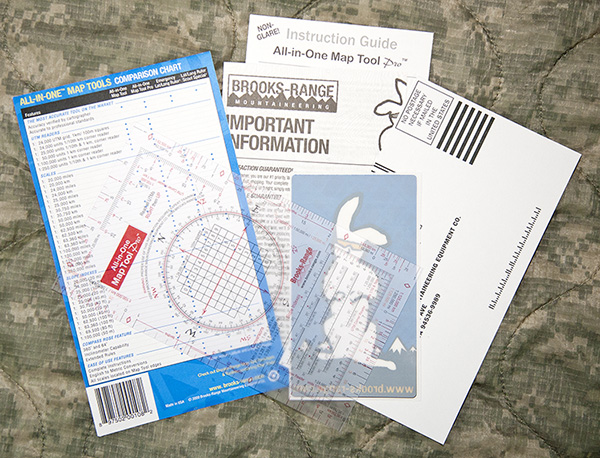
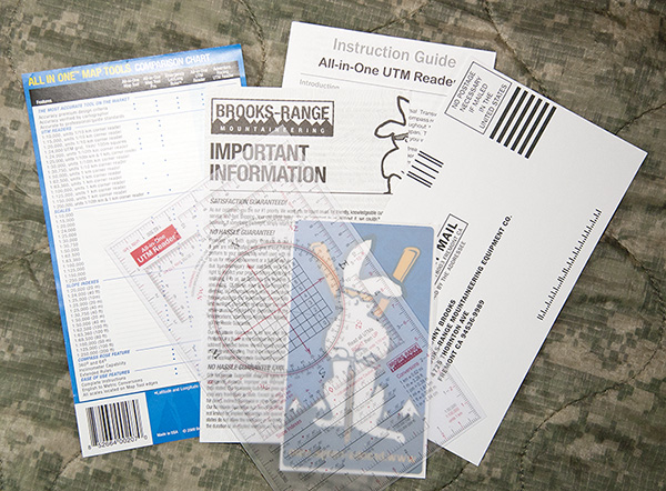
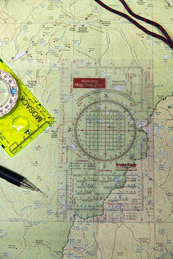
Upon receiving this very cool set of navigational aids, I quickly began to check it out. My first impression was that these look well made and quite detailed in the information available on them. I think it'll be easier to talk about each item separately, except that the All-in-One Map Tool Pro and UTM Grid Reader are so close in appearance and construction, that I'll cover those together for this report. I will then report on the use and capabilities of each item separately in the Field Report and Long Term Report as required. The Brooks-Range All-In-One UTM Grid Reader - The manufacturer's website states, "is an essential tool for backcountry adventurers, and contains 8 UTM's, scales, and 12 slope indexes commonly used on backcountry topographic maps in the US, Alaska, Canada, Europe, New Zealand and Japan. Thin but durable, our UTM Grid Reader is as essential for backcountry travel and orienteering as a map and compass."
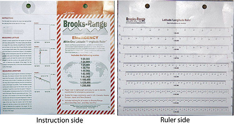
The Map Tool and the UTM Grid Reader above, are constructed from a flat sheet of opaque or semi-clear colored, "non-glare" plastic. There is a plethora of scales and graphs and other information available on each. The print is variable in font sizes and some are in red and others in black colored type. They each have on them a printed warning stating, "WARNING: Proper use of this information requires expert training!", which needless to say is a bit intimidating, so this should be interesting. I have also noticed that the plastic sheet material of these tools seem to have a slight static cling to each other and to paper when it is laid flat against them. This cling effect has both the good in that it stays with the map, but also the bad in that it is somewhat difficult to pick up off a flat surface. Sliding it to the edge of the table was the best way for me to pick it up. The Emergency Latitude / Longitude Ruler - The manufacturer's website states, "Most backcountry travelers use the Universal Transverse Mercator (UTM) system for planning and navigation. Helicopter and air rescue crews use the lat/long system. Designed by team of professional mountain guides and cartographers, this 4x7 paper lat/long ruler is lightweight and fits easily into the Brooks-Range Field Organizer or a pocket for quick reference in an emergency."
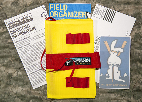
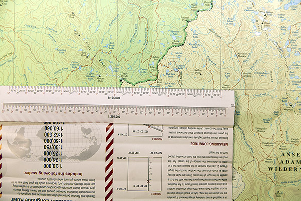
The "Ruler" is simply a piece of printed paper that is intended to be folded at whatever point where the ruler guide matches to the scale I wish to use on a given map. On one side there is a series of scaled rulers covering 10 different scales from 1:20,000 through 1:250,000. My first impressions of this is that the concept is good and there is some weight savings although essentially minuscule, but that this is only constructed from a standard sheet of paper that easily rips concerns me that this will not last. When I first received this, I found it had been "folded and sealed" with a circle of sticky tape commonly found on boxes and containers to keep them from being opened prior to sale. I attempted to just carefully remove the tape from the paper, but the paper tore instead. I already see that I'll have to be quite careful with this item. The tear in the paper can be seen in the photo below at the left edge of the instruction side, under the semicircle of tape. The Field Organizer - The manufacturer's website states, "Designed to hold our Rite in the Rain® field books, this bright yellow, waterproof cover organizes all of the items you use with your field book."
I can quickly see that I should have no trouble locating this item as it is very brightly colored. There are sewn loops (both inside and outside) for securing 6 pens, pencils, etc.; a squared pocket inside that looks like my compass might fit and 6 additional pockets to organize multiple map tools, a notebook and even maps if folded to fit. My Yosemite National Park and Vicinity topo waterproof map in 1:125,000 scale which is folded by the printer/manufacturer, fits perfectly inside. My folded map measures 7.25 X 4.25 in (18.41 cm X 10.8 cm). These are basically the same dimensions for the Organizer when closed. It opens like a book so the width then is 9 in (21.6 cm). There is a handy hook and loop strap to secure the Organizer closed when not in use. READING THE INSTRUCTIONS
There are a lot of instructions. The Map Tool Pro has 9 pages of instructions, while the UTM Reader stretches into 10 pages. The instructions all seem pretty straightforward. There are also hints and diagrams to assist in understanding how to use these tools. Each tool's package includes a pamphlet of "Important Information" which contains a "Satisfaction Guaranteed!" and "No hassle Guarantee!" section along with company contact information and requirements for merchandise returns, repair services, proper care and storage and cleaning of the products they offer. It appears that this pamphlet is intended to provide information to cover other products that Brooks-Range Mountaineering Equipment Co. sells as well. TRYING IT OUT
I must admit first that I am definitely not a cartographer, so I will not be able to independently verify the true accuracy of these tools and will leave that up to the manufacturer and individuals who choose to use these tools. Summary
Over all, I am impressed with this product and the manufacturer. On the surface, everything seems to be well made and thought out. I am interested both, in how these tools will work for me and in my ability to navigate through the instructions, charts, guides, and more as I learn the capabilities of these tools and my understanding of them. Did you like the pun? Well I have a lot of work to do ahead of me with this test so I am heading out. FIELD LOCATIONS AND CONDITIONS
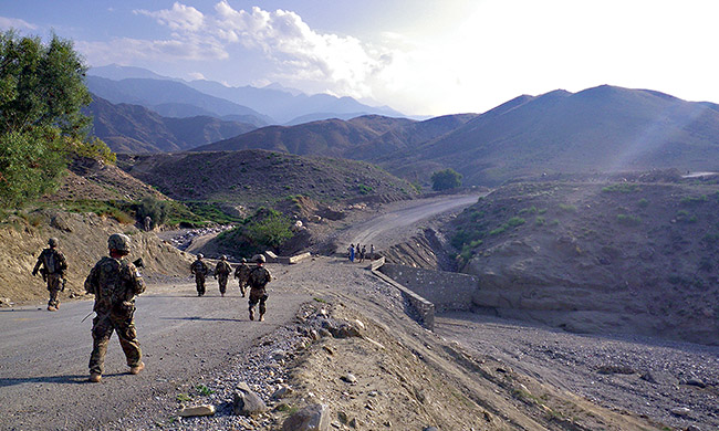
During this testing phase, I have been in Nangarhar Province, located in eastern Afghanistan for the majority of the past two months. I have since spent 9 days with 2 over night trips with 3 nights in the field with my Map Tools during this phase. I have also practiced with them while "at home" at base camp as well. PERFORMANCE IN THE FIELD
During this series Ive used the Map Tools to plan for trips/missions as well as orient in the field here in Afghanistan. While I am unable to provide photos of the specific maps used as they belong to the military, I have been able to navigate successfully in a variety of map scales covered by these tools. I have noted that these tools have a lot of available information on them and as a result, I have not yet been able to utilize or test every feature available. I have however, been able to use them in the following scales - As I stated above, the Map Tools provide a lot of information on each of them. Having said this, once I have identified the correct scale of the specific map and matching scale on the Map Tool I am using, it becomes pretty straightforward. Having knowledge of standard navigation with a map and compass is required. Spending a little time with the tools and a map along with the provided instructions also helps to become familiar with their ease of use. I am older (at 48) than virtually everyone I work with here in Afghanistan, so when identifying easier navigational routes to get to a specific location, these map tools have worked very well for me. I have also been quite appreciative of the Slope Index scales. They provide an easy way to identify how steep a slope is quickly by providing a more visual reference in degrees of incline or decline. In using the UTM Corner Ruler option on the UTM Reader at the scales of 1:50,000, 1:63,360, 1:125,000 and additionally at 1:62,500 (although I didn't use this last scale), I found that the UTM scale only goes up to 5 rather than the standard 10 units. This is also covered within the instructions and guidance is provided to show how to still utilize these scales easily. Basically, knowing how to use a compass and UTM scale in navigation seems to be the basis for being able to use these Map Tools. The Brooks-Range Map Tools for me, have worked well. They seem to remain flexible even in cooler climates and their opaque color is transparent enough to allow the map's contour lines and related information to remain visible through them. I did note that my All-in-One Map Reader tool was bent at the corner after removing it from my pack. This bending of the plastic tool caused some minor clouding of the opaqueness of the tool, so it looks whiter in this area of where the bend was. I'll have to try to pack the tools away from harder items within my pack to ensure this does not continue to happen. The brightly colored Field Organizer is easy to locate within my pack and shows no signs of wear to date.
The paper All-in-One Latitude/Longitude Ruler too, has performed well so far. I have not had any further issues with it tearing, but admittedly, am being very careful with how I handle it. I did note that the scale of 1;125,000 as listed on the Ruler does not quite match the same scale as displayed on the map as can be seen by my photo above. SUMMARY
So far, I have found these Map Tools to be very helpful, lightweight and easy to use, both at home and in the field. They have a lot of information on them that seemed a little daunting at first, but once the correct scale on the tool is matched with the proper map, they are worth their weight. I can not stress how important it is to have knowledge of navigation and familiarity with these tools prior to having to rely on them in an emergency situation. Spending a little time with them first can avoid a lot of problems later. LONG-TERM TEST LOCATIONS AND CONDITIONS
During this testing phase, I have been in Nangarhar Province, located in eastern Afghanistan for the entirety of the past two months. I have since spent 17 days with 4 over night trips in the field with my Map Tools during this phase. PERFORMANCE IN THE FIELD
During this test period, the map tools worked splendidly. I found them easy to use, convenient and was able to use them with a multitude of map scales as listed above. I have used the map tools as both a primary as well as a back up tool for other navigational aids to include standard GPS and military software. As I mentioned in the Field Report, I found a slight measurement difference on the available scales on the paper ruler to the map. I did not find this a deal breaker at all. Inaccuracies that I have found in deviations of scales from differing maps to the paper ruler, have been easy to work around and a reminder that I can never completely rely upon any one tool when in the field. It was a very minor problem to me anyway. SUMMARY
The map tools are lightweight and easy to use once I had taken the time to put in some practice. The early bend in the All-in-One UTM Reader that happened from my packing in my backpack was a lesson learned. I was more careful about making sure there was a flat spot away from hard corners of other items inside my pack. The Map Reader, although having a small clouded look to the opaque plastic, is not really affected by the obvious change in color at the bend and I have been able to work with it as-is. The printing is quite small so if I were one needing reading glasses, I would probably want to pack them or a small magnifying glass to make reading the information on the UTM Reader as well as the Map Tool. I believe that my practicing with these tools before taking them out to the field helped me identify my weak points. Read more reviews of Brooks Range Mountaineering Equipment Co gear Read more gear reviews by Michael Mosack Reviews > Navigation and Map Gear > Accessories > Brooks Range Map Tools > Test Report by Michael Mosack | ||||||||||||||||||||||||||||||||